

Snippets and stories
Discover the rich history of our area
Origins
Land maps from the 1800s, like the one on the left, show the site south of Kensington Road almost entirely occupied by these gardens and nurseries.

Map from the 2014 Ordnance Survey
1862-1865 Prince of Wales Terrace built by the builder Thomas Cawley
1862-1867 3-15 Palace Gate built by W Cubitt and Company
1864-1869 Meropolitan and District Railway built
1875-1884 De Vere Gardens, De Vere Mews and Laconia Mews built
1894 St Mary Abbots Mission Hall and Infant School built (currently Thomas’s St Albans Grove site)
1924 Telephone Exchange, South End Row built by Office of Works
1936 Cottesmore Court, Stanford Road designed by Gerald Unsworth
Imagine a neighbourhood with fertile fields and clean air, known for its market gardens and nurseries, near to the centre of a busy capital city - this was our Victoria Road Area for centuries before the bustle caught up with us!

Land use map c 1800 by Thomas Milne
It was only the speculative building projects of the mid 19th century onwards that started the transformation to the streetscape we see today.
Have a look at the map on the right to see how the building work unfolded, starting with 10-16 South End Row by local builder Jonathan Hamston (a name familiar to us from Hamston House in Kensington Court Place). “It is all very clean and neat and astonishes visitors who a few years ago beheld scarcely a house on the spot” was the reaction of the English critic, essayist and poet Leigh Hunt in 1855 when describing the area around Canning Place, Victoria Grove and Launceston Place.
1805-6 10-16 South End Row built by carpenter, Jonathan Hamston
1837-43 Inderwick Estate built (Canning Place, Victoria Grove, Launceston Place, 2-72 even Gloucester Rd incl Gloucester pub)
1840-1852 Vallotton Estate’s chief period of development which began in 1829 and ended around 1880s (Victoria Rd, Albert Place, St Albans Grove, Douro Place, Cottesmore Gardens)
1850-1851 Christ Church built to the designs of Benjamin Ferrey
1850-1851 Great Exhibition in Hyde Park. Hippodrome built between what is now Victoria Road and De Vere Gardens
Our Blue Plaque Members
Many illustrious names have lived on these streets. You might have stumbled upon some of the famed blue plaques already.

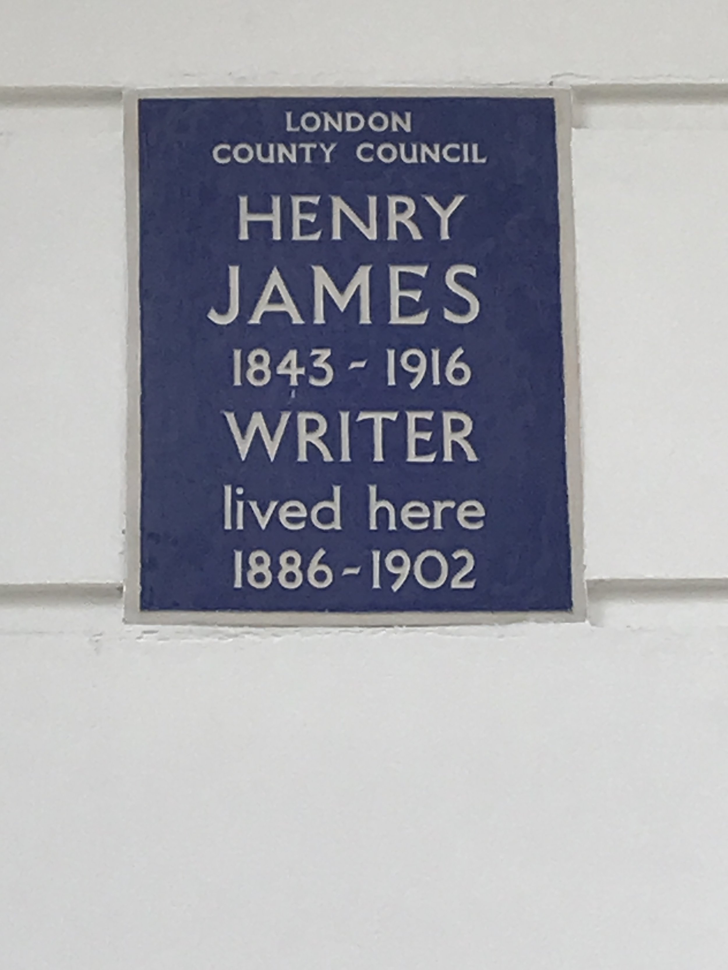
Henry James
American-British author, widely known for his ghost-story novella The Turn of the Screw
Lived in De Vere Gardens from 1886 to 1902

Robert Browning
English poet and playright
Lived in what is now Browning House, De Vere Gardens for two years until his death in 1889

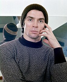
Rudolf Nureyev

One of the greatest male ballet dancers of all time
Lived on Victoria Road

Samuel Palmer

British landscape painter, etcher, printer and writer
Lived at Douro Place from 1851-1861

Edward Corbould
Victorian painter specialising in horses and dogs, and art tutor to Queen Victoria’s children
Lived at Eldon Lodge, Victoria Road

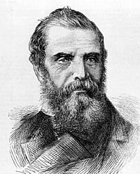
Richard Ansdell
Eminent Victorian painter, known for depicting animals and genre scenes
Lived in Lytham House in St Albans Grove from 1862-1884

Currently concealed by Thomas’s School building works!

Did you know we had a Hippodrome?
Our Hippodrome - an open arena for events including horse shows and races - was built around 1850 as a ‘spillover’ from the Great Exhibition in Hyde Park.
Built on the land between what is now Victoria Road and Palace Gate, it boasted seating for 14,000 people!
According to The Lady’s Newspaper of May 1851, there were ‘incredible feats of French equestriennes, probably the best horsewomen in the world’, taking part in chariot races, along with ostrich races, a monkeys’ steeplechase, and brass bands playing. The Hippodrome closed in 1852 but a riding school on part of the site continued for some twenty years thereafter.
Our lovely mews and mews arches

In 1908 the first mews was converted into residential accommodation - today these properties are highly valued, and contribute hugely to the character and visual appeal of the area.
The word ‘mews’ comes from the Royal Mews at Charing Cross, where the royal hawks were ‘mewed’. When they were converted into stables during the reign of Henry VIII, the word came to mean a stables around a yard or alley.
The mews arches helped to maintain the architectural integrity of the area behind horses’ stables and provided accommodation for carriages, grooms and stablehands.
Milestone Hotel
As for the building itself, the house was built in 1884 - the first Baron Redesdal, the grandfather of the famous Mitford sisters, lived there for a time - and became a hotel in 1922.
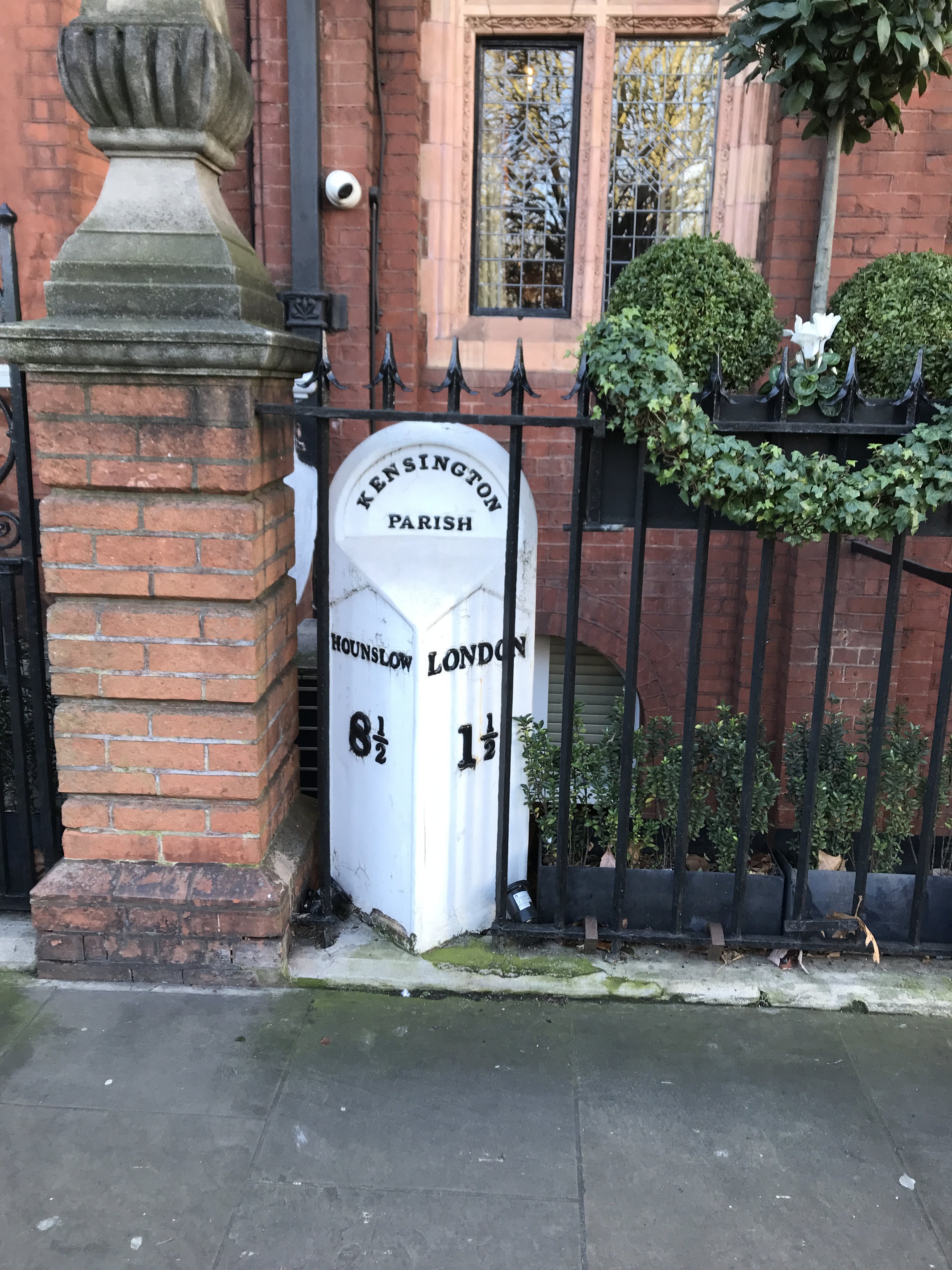
You can still see the milestone today outside the hotel
Located opposite Kensington Palace, the hotel is named after the old cast-iron milestone which is still in its original position within the hotel’s boundary.
These stones informed travellers of direction and distances - around 9,000 survive in the UK today. As the current Head Porter at the hotel put it, ‘they were a sort of Victorian sat-nav’.
The many purposes of these stones also included helping coaches remain on schedule, and assisting calculating charges for changing horses at coaching inns. The distances between milestones were even used to work out postal charges before uniform rates were introduced in 1840.
Architectural Legacy of World War II
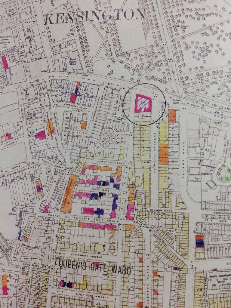
This map depicts the extent of our neighbourhood’s destruction in Second World War bombing raids. Some buildings in Douro Place, St Albans Grove and Eldon Road totally destroyed; others, for example in Victoria Road, damaged beyond repair. And at the top of De Vere Gardens/Victoria Road a large circle depicts damage caused by V1/ V2 rockets. A sobering reflection on what our precedessors suffered and how successfully the area has since regenerated .
Key:
Black = Total destruction
Purple = Damaged beyond repair
Red = Seriously damaged – doubtful if reparable
Salmon Pink = Seriously damaged – reparable at cost
Orange = General blast damage – not structural
Yellow = Blast damage – minor in nature
Green = Clearance areas Circle Rocket V1 or V2